On this day in (engineering) history…
Construction of the Afsluitdijk is completed, Netherlands, May 28, 1932
Your country is in constant danger of flooding and when, during one dreadful night, your coastline is devastated by a huge storm - ships wrecked, homes destroyed, and people killed - what do you do to stop it happening again?
Build Europe’s longest dam, the Afsluitdijk.
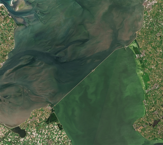
A satellite photo of the Afsluitdijk, The Netherlands, 30 June 2018. The Afsluitdijk changed the Zuiderzee into the IJsselmeer. To the north of the Afsluitdijk is the Wadden Sea, to the south is the Ijsselmeer. Source: Wikimedia Commons
The issue
The Netherlands is referred to as one of the Low Countries for a reason. Mostly flat, with the currents, tides and winds of the North Sea battering the coast, the country has battled with the whims of the sea for centuries.
When this part of Europe was a province of the Roman Empire, the coast around what became Amsterdam was a mix of marshland, lakes and rivers that drained into the Rhine. Over the next millennium, the region was subject to rises in sea level that flooded the land and drowned the marshes, creating what became known as the Zuiderzee (Southern Sea), an inlet of the North Sea almost within the heart of The Netherlands itself.
The Dutch response to such an unpredictable body of water was to build a network of dikes around the country and around the Zuiderzee to protect farmland, villages, towns and homes. Over time, people became highly skilled at water management and land reclamation. But the sea would still claim its rights over the land.
Overnight, on January 13, into January 14 1916, a great storm brought destruction to the Dutch coast, especially the Zuiderzee. Force ten gales and a storm surge into the Zuiderzee, broke dikes, battered communities and destroyed the island of Marken. In all 53 people died. It gave the impetus to actually do something to solve the problem.
The solution
This disaster drove the country to look for a solution, and one was ready to hand.
Back in 1891, civil engineer Cornelis Lely developed the first plan to close the Zuiderzee - between Den Oever in North Holland province and the village of Kornwerderzand in Friesland province - and open it to land reclamation. The local fishing industry opposed the plan, because closing off the inlet from the North Sea meant ending its status as a fishing ground. Fishermen would lose their way of life, livelihoods and risk destitution for themselves and their families. Others complained the scheme was too big and too expensive.
After the storm, opposition melted away. Parliament authorised the project in 1918, but it took until 1927 to begin work.
This doesn’t mean nothing happened. A trial dam was built, the Amsteldiepdijk, connecting North Holland to what was then Wieringen island, a distance of 2.5km.
Construction of Afsluitdijk (literally, ‘Lock Dyke‘) began at four points, one apiece either side of the narrows and at two construction islands in the channel. Steel reinforced willow rods were driven into the seabed. A large portion of the dam was built (on the North Sea side) with layer upon layer of boulder clay, or till.
The last tidal channel, the Vlieter, was finally filled in on May 28, 1932, two years ahead of schedule.
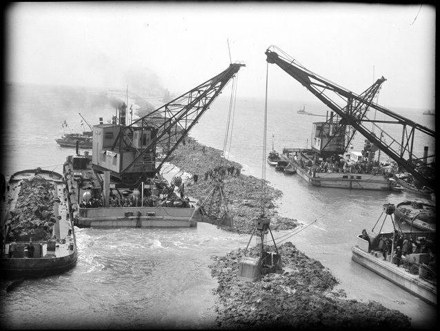
Ships and cranes during the closure of the closing hole 'De Vlieter'. Zuiderzee Works in 1932. Source: Wikimedia Commons
After the build-up breached the water, the base was reinforced with basalt rock and willow switches. The boulder clay was backed up with sand overlaid with clay. Grass was planted on the clay to hold it together.
The dam measures in at 32 kilometres (20 mi), 90 metres (300 ft), wide and is 6.7 metres (22 ft.) high along the section at Friesland, rising to 7.4 metres (24 ft.) where it blocks the Vlieter deep channel. It was built with 23 million cubic metres of sand and 13.5 million cubic metres of boulder clay. In all, the effort used the muscles of a total of ten thousand workers, 27 dredges, 13 floating cranes, 132 barges and 88 tugs.
The finishing touches
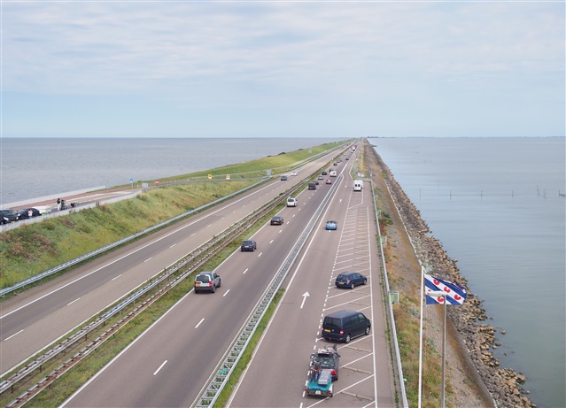
Afsluitdijk with the Wadden Sea (a part of the North Sea) on the left and the IJsselmeer on the right. Source: Wikimedia Commons
This was not the end. It took until September 25 to raise the dam to the necessary height and link North Holland to Friesland with a road. On September 20, the Zuiderzee became the Ijsselmeer, a freshwater lake (although it was still salty at this point)
Both ends of the dam were equipped with shipping locks and water sluice gates regulate the water level in the new Ijsselmeer, which still ran the risk of flooding from the rivers running into what had been the open sea.
The Afsluitdijk has been worth the effort, protecting the country from the flooding that bedeviled it in the past. It took substantial damage in the great storm of 1953 and its height was raised to 7.4 metres.
On 23 September 1954, the occasion of his centenary, Queen Juliana unveiled a monument to Cornelis Lely, the engineer who produced the original design.
Now, in the era of climate change, Afsluitdijk is more important than ever, even if it has one flaw. It blocked the path into new Ijsselmeer for migratory fish. This is now being remedied with a new fish passage, as part of the process to reinforce the dam and upgrade it to fend off the rising sea levels of climate change.
How can the Dutch experience of water management be applied in countries such as the UK, to deal with effects of climate change (extra rainfall and rising sea levels)?
 By Stephen Phillips - IET Content Producer, with passions for history, engineering, tech and the sciences.